
Proposed Plan Change 3 – Kārewarewa Urupā
Consultation has concluded
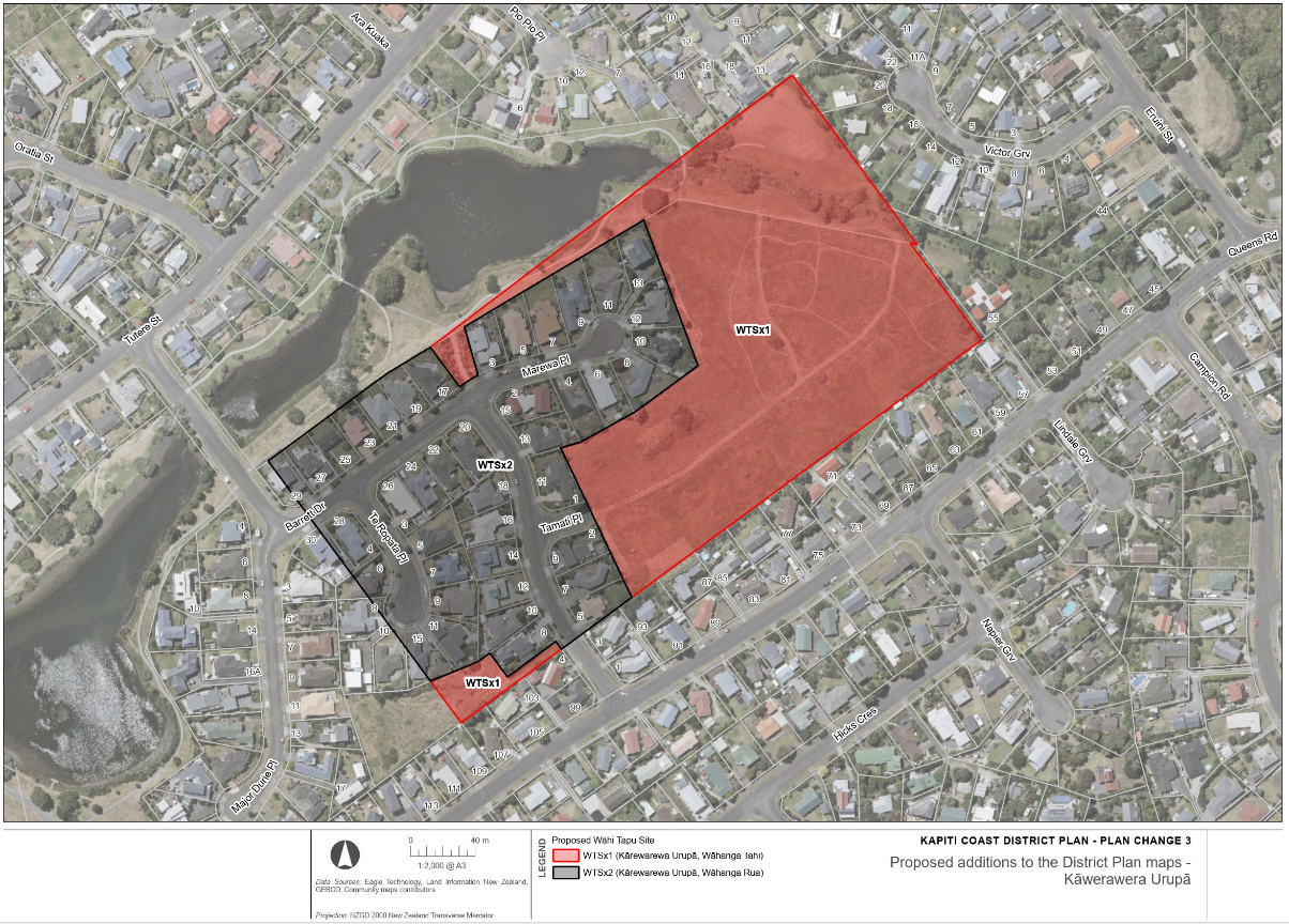
Proposed Plan Change 3 recognises and provides for Kārewarewa urupā as a site of significance to Māori. Kārewarewa urupā is located in the area around Barrett Drive, Te Ropata Place, Marewa Place, and Tamati Place at Waikanae Beach.
This plan change includes the following amendments to the Operative District Plan 2021:
- adding Kārewarewa urupā to Schedule 9 of the District Plan (Sites and Areas of Significance to Māori)
- amending the District Plan maps to include Kārewarewa urupā.
Status: Submissions closed 5pm, Friday 1 November 2024.
Immediate legal effect
PC3 has immediate legal effect on and from Wednesday 18 September in accordance with section 86B(3)(d) of the Resource Management Act 1991. This means that the District Plan rules for sites and areas of significance to Māori will apply to subdivision, use, and development at Kārewarewa urupā on and from this date.
Making a submission
Anyone who wished to make a submission on this plan change was able to do so. Submissions closed 5pm, Friday 1 November 2024.
Please email the District Planning team if you have any questions.
Implications for land use and subdivision
The plan change proposes to classify areas of the land at Kārewarewa urupā as either “Wāhanga Tahi” or “Wāhanga Rua” in the District Plan. This triggers the application of some rules in the District Plan, as described below. SASM refers to the Sites and Areas of Significance to Māori chapter of the District Plan.
Land disturbance/earthworks
Wāhanga tahi overlay
Rule SASM-R2 (permitted): Permitted land disturbance is limited to fencing of the perimeter of the site, subject to an accidental discovery protocol.
Rule SASM-R10 (restricted discretionary): Other land disturbance and earthworks require resource consent as a ‘restricted discretionary activity’, subject to an accidental discovery protocol.
Wāhanga rua overlay
Rule SASM-R3 (permitted): Up to 10m3 of land disturbance or earthworks is permitted per year, subject to an accidental discovery protocol.
Rule SASM-R11 (restricted discretionary): Other land disturbance and earthworks require resource consent as a ‘restricted discretionary activity’, subject to an accidental discovery protocol.
Additions/alterations of existing lawfully established buildings
Wāhanga tahi overlay
Rule SASM-R10 (restricted discretionary): Additions and alterations require resource consent as a ‘restricted-discretionary activity’, subject to an accidental discovery protocol.
Wāhanga rua overlay
Rule SASM-R3 (permitted): Additions and alterations are permitted, subject to not including a basement or in-ground swimming pool.
Rule SASM-R11 (restricted discretionary): Other additions and alterations require resource consent as a ‘restricted-discretionary activity’, subject to an accidental discovery protocol.
Construction of new buildings
Wāhanga tahi overlay
SASM-R18 (non-complying): New buildings require resource consent as a ‘non-complying activity’.
Wāhanga rua overlay
Rule SASM-R3 (permitted): New ancillary buildings are permitted, subject to not including a basement or in-ground swimming pool.
Rule SASM-R11 (restricted discretionary): Other new buildings require resource consent as a ‘restricted-discretionary activity’, subject to an accidental discovery protocol.
Subdivision
SUB-DW-R10 (restricted discretionary): Subdivision of land that does not increase the number of allotments within which the site of significance is located requires resource consent as a ‘restricted discretionary’ activity.
SUB-DW-R15 (discretionary): Subdivision of land that increases the number of allotments within which the site of significance is located requires resource consent as a ‘discretionary’ activity.
Relationship to Plan Change 2: Intensification (PC2)
In August 2022, Council included the proposal to incorporate Kārewarewa urupā into Schedule 9 of the District Plan (Sites and Areas of Significance to Māori) as part of its “Intensification Planning Instrument”, which was more commonly known as Proposed Plan Change 2. The Council’s reasons for incorporating the urupā into the District Plan as part of PC2 are described in the Council’s Section 32 Evaluation Report for PC2 [PDF 2.82 MB].
In 2023, after hearing submissions and evidence, the Independent Hearings Panel for Proposed Plan Change 2 recommended to Council that Kārewarewa Urupā be introduced into Schedule 9 of the District Plan. Council accepted this recommendation as part of its decisions on the plan change, and PC2 became operative on 1 September 2023.
In 2024, the Council’s decision to incorporate Kārewarewa urupā into the District Plan as part of PC2 was judicially reviewed by the High Court. The judicial review was brought against the Council by the Waikanae Land Company, a landowner within the urupā area. The judicial review was not about the merits of incorporating Kārewarewa urupā into Schedule 9 of the District Plan. Rather, the Court was asked to determine whether the Council had the legal power to do so as part of PC2. This is because PC2 was a unique ‘one-off’ plan change required by the government as part of its direction to councils across New Zealand to incorporate the Medium Density Residential Standards into their district plans. As an Intensification Planning Instrument, PC2 was subject to limitations on its scope set out in the Resource Management Act 1991 (RMA), and the Court was asked to determine whether incorporating Kārewarewa urupā into Schedule 9 breached these limits.
The Court delivered its decision on 21 June 2024. The Court found that the Council did not have the power to incorporate Kārewarewa urupā into the District Plan in the manner that it did, because it was outside the scope of what could be included in an Intensification Planning Instrument under the RMA. As a result, the Court cancelled the scheduling of the urupā. However, the Court also recognised that the Council could incorporate Kārewarewa urupā into the District Plan through an ‘ordinary’ plan change under Part 1 of Schedule 1 to the RMA. PC3 achieves that purpose.
Definitions
Classes of activity under the RMA
Permitted activity
A resource consent is not required for the activity if it complies with the requirements, conditions, and permissions, if any, specified in the Act, regulations, plan, or proposed plan.
Restricted discretionary activity
A resource consent is required for the activity and the consent authority’s power to decline a consent, or to grant a consent and to impose conditions on the consent, is restricted to the matters over which discretion is restricted (whether in its plan or proposed plan, a national environmental standard, or otherwise. Additionally, if granted, the activity must comply with the requirements, conditions, and permissions, if any, specified in the Act, regulations, plan, or proposed plan.
Discretionary activity
A resource consent is required for the activity and the consent authority may decline the consent or grant the consent with or without conditions. Furthermore, if granted, the activity must comply with the requirements, conditions, and permissions, if any, specified in the Act, regulations, plan, or proposed plan.
Non-complying activity
A resource consent is required for the activity and the consent authority may decline the consent; or grant the consent, with or without conditions, but only if the consent authority is satisfied that the requirements of section 104D are met and the activity must comply with the requirements, conditions, and permissions, if any, specified in the Act, regulations, plan, or proposed plan.
Urupā
Under the District Plan urupā means (Māori) burial ground.
Wāhanga
This term is not defined in the District Plan or in the RMA. However, the word “wāhanga” can be considered in this context to mean ”classification”.”Tahi” means “one” and “rua” means two.
Wāhanga tahi
Schedule 9 of the District Plan describes this classification as follows:
- Type – Urupā (Māori burial grounds) and parekura (battlefield)
- Key development threats – Land disturbance, earthworks
- Sensitivity to development – High – sites are largely unoccupied/undevelopedDesired level of protection - High – rules intended to provide a high level of protection as there is a high-risk land disturbance will encounter koiwi
Wāhanga rua
Schedule 9 of the District Plan describes this classification as follows:
- Type – Urupā (Māori burial grounds), pā (village), papakāinga (place of settlement)
- Key development threats – Land disturbance, earthworks, construction of new buildings and alterations, additions and relocations of existing building, and network utilities
- Sensitivity to development – Moderate – land is modified and currently occupied by residents and/or businessesDesired level of protection - Moderate – rules intended to allow for a reasonable level of development to occur provided land disturbance volumes are reasonably low and discovery protocols are followed
Wāhi tapu
A site or an area which is sacred or spiritually meaningful to tangata whenua. Wāhi tapu may be associated with creation stories of tangata whenua, a particular event (such as a battle or ceremony); it may be where the whenua (placenta) was returned to the earth, or where a certain type of valued resource was found. (District Plan definition).
Map of affected area

See a larger image of this map, or see page 5 of Proposed Plan Change 3 – Kārewarewa Urupā
Notification documents
Supporting documents for notification
-
 Section 32 Evaluation Report – Kārewarewa Urupā
-
Section 32 Evaluation Report Appendix A – Kārewarewa Urupā Report (Waitangi Tribunal, 2020)
-
Section 32 Evaluation Report Appendix B – Information from PC2 Relevant to Kārewarewa Urupā
-
Section 32 Evaluation Report Appendix C – Independent Hearings Panel’s Report on PC2
-
Section 32 Evaluation Report Appendix D – Iwi Authority Feedback on PC3
Council website
Who's Listening
-
Kāpiti Coast District Council